Applying Roadscor for safe road design in Noord-Brabant (NL)

The possible conflicts and their severity depend on the intersection design, the type of road users, traffic rules and behavior.
The Challenge
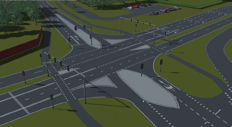
The Province Noord-Brabant (The Netherlands) is the road authority responsible for provincial roads' (N-roads) design, maintenance, and safety. In 2024 the Province launched the Zero Vision plan (Brabants Verkeersveiligheidsplan - BVVP) aiming to halve the number of traffic victims by 2030 compared to 2019. The plan emphasises improvements in infrastructure, behaviour and enforcement, with special attention to cyclists, distracted drivers and inexperienced road users. As part of the Zero Vision, the N286 was identified as a road in need of improved safety.
The intersection was known for red light violations, leading to increased safety risks and the concerns of the Province on the likelihood of dangerous interactions between road users, particularly at peak times or during complex traffic flows.
The intersection was selected to be assessed as part of a program by SWOV Institute for Road Safety Research, which conducted camera observations to determine road user behaviour and risk identification. The Province saw the opportunity to compare this approach against the conflict analysis, challenging Roadscor to perform the assessment with minimal data input. Roadscor worked solely based on the vLOG traffic light data collected by sensors embedded in the road surface, which continuously log vehicle detections, signal changes, and priority requests at intersections.
The Solution
The Province Noord-Brabant trusted Roadscor to perform safety analysis and to suggest design measures to improve the road safety in the intersection.
Roadscor assesses safety based on the probability and severity of conflicts of the routes of road users. This approach is enabled by software originally developed by Roadscor’s partner Siemens for the safe introduction of autonomous vehicles according to ISO21448 (SOTIF), where it is used to detect unknown-unsafe scenarios.
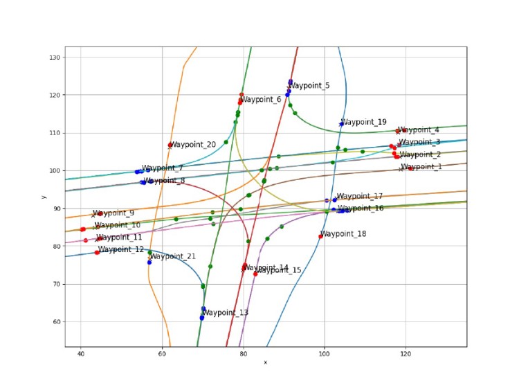
Although the vLOG data provided insight into the routes, intensities and behaviour (speed and red light violations) or motorised traffic and cyclists, data on pedestrian behaviour was lacking as there was no dedicated pedestrian crossing at the intersection. The vLOG data also cannot provide input on cyclists driving against traffic. For this reason, the vLOG data was complemented with synthetic data for these routes.
In total Roadscor considered over 4,000 different traffic paths of the different road users, including varying lateral deviations and speed profiles, over more than 700 routes through the intersection. These were simulated against each other in time to determine the probability and the controllability (the degree to which the incident could potentially be avoided by a road user) of the conflicts.
Making an impact
Roadscor’s first iteration of the current signalized intersection layout simulated 4,033 traffic paths and revealed 53 collisions (24 car-to-car, 25 car-to-pedestrian, 4 car-to-bicycle) and 72 near-misses, resulting in a total risk score of 46.54. Severity analysis showed 25 minor, 7 moderate, 9 serious, and 12 fatal possible conflicts. These findings confirmed the intersection’s high-risk nature and highlighted the complexity of managing multimodal flows at a busy urban junction.
The second iteration incorporated advised measures from Haskoning’s traffic engineers, including adjusted signal timings and clearance intervals. This redesign demonstrated a significant improvement: 44 collisions (20 car-to-car, 22 car-to-pedestrian, 2 car-to-bicycle) and 68 near-misses, reducing the total risk score to 15.34—a nearly 67% decrease in overall risk exposure. Severity analysis for this iteration showed 21 minor, 6 moderate, 8 serious, and 9 fatal possible conflicts. While the redesign substantially lowered overall risk and minor events, the persistence of serious and fatal conflicts indicates further refinements are needed, particularly optimizing green phases and introducing dedicated pedestrian crossings. These insights provide a strong foundation for evidence-based decisions, helping the region move closer to its Vision Zero ambitions.
Lessons learnt
A key enhancement in this phase is the integration of accident severity analysis, now fully embedded in simulation outcomes. Severity-weighted risk indicators combine Roadscor’s simulations with reference data from VUFO and the German In-Depth Accident Study, enabling not only conflict likelihood quantification but also assessment of potential consequences. Alongside probability and controllability, these indicators provide a Safety Performance Indicator directly linked to prevention, mitigation, and social cost estimation.
Equally important, this project proved that robust safety analysis is possible with minimal input data. For this intersection, Roadscor relied mainly on VLOG traffic signal data for flows and timings, supplemented with synthetic pedestrian and cyclist scenarios—including wrong-side crossings. This allowed a digital twin without costly field studies or crash history. During analysis, some scenarios showed high unexpectedness despite appearing normal in video. This was traced to lateral vehicle movements (lane changes) influencing scores. An adjustment was tested to avoid false critical flags; early results improved accuracy, though further refinements are needed. By combining scalable modeling, severity-weighted indicators, and algorithm improvements, cities can prioritize interventions with the highest safety return.