Using connected vehicle data to identify road safety risks in London

The Challenge
Urban transport authorities such as Transport for London (TfL) manage one of the most complex road networks in the world. Improving road safety, reducing congestion and maintaining reliable public transport services requires accurate and timely data. Traditionally, many traffic management and safety interventions rely heavily on historical crash data. However, collision data can take more than a year to be fully collected and analysed, making it difficult for authorities to react quickly to emerging risks or traffic patterns.
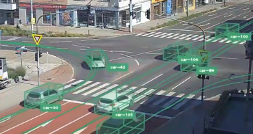
Another challenge is gaining a comprehensive understanding of how different types of vehicles - cars, buses, light commercial vehicles (LCVs) and heavy goods vehicles (HGVs) - interact across the network. Without granular and real-time mobility data, it can be difficult for city planners to identify high-risk road segments, understand bus delays at intersection or detect freight stopping patterns that affect congestion and infrastructure planning.
The Solution
Compass IoT deployed its Road Intelligence platform and a series of custom dashboards for TfL. The platform integrates anonymised connected vehicle data, generated by sensors in modern vehicles, with existing TfL datasets such as bus telemetry and collision records. This combined dataset provides transport planners with a dynamic and holistic view of traffic behaviour across the entire London road network.
During the project, Compass IoT’s data science team developed and iteratively refined four finalised dashboards currently in active use by TfL and additional tools still under development. These dashboards support several use cases, including identifying high-risk road safety locations through near-miss analysis, analysing bus journey variability at intersections and understanding where freight vehicles stop across the London network. Connected vehicle data was continuously collected and processed in real time, allowing TfL to visualise traffic patterns, near-miss events and travel times without requiring new roadside hardware or infrastructure.
Making an impact
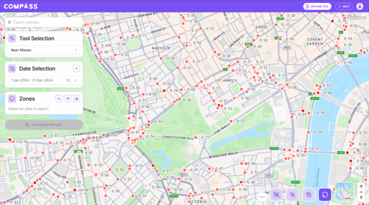
The project generated valuable insights to support data-driven traffic management and road safety improvements across London. Using combined collision and connected vehicle near-miss data, the platform identified 22,748 collision clusters containing 45,899 near-miss events, as well as 14,170 near-miss clusters across the network. These insights enable TfL to identify high-risk locations and prioritise targeted safety interventions.
The dashboards also provided new insights into bus performance and freight movement. Analysis of bus routes revealed average waiting times of up to 4.4 minutes at some intersections and queue lengths of up to 323.78 metres, helping TfL investigate signal optimisation and improve bus reliability. In addition, freight analysis showed an average stop time of 76 minutes, helping TfL and local boroughs identify potential locations for rest areas or charging infrastructure.
Finally, the use of connected vehicle data significantly improved the speed of analysis. While traditional collision data can take over 12 months to become available, near-miss data from connected vehicles can be processed within 1–2 days, allowing TfL to respond more quickly to emerging road safety risks.

Lessons learnt
The project demonstrated the significant value of integrating connected vehicle data into urban transport management systems. By combining real-time mobility data with traditional datasets such as collision and bus information, transport authorities can move from reactive planning based on historical incidents to more predictive and proactive traffic management. This approach enables earlier identification of risk patterns and more targeted interventions to improve road safety and network performance.
Another key lesson was the importance of iterative collaboration between technology providers and transport authorities. Throughout the project, dashboards were continuously refined based on feedback from TfL staff, ensuring that the tools aligned with operational needs and planning workflows. The pilot also highlighted that infrastructure-free solutions - using data collected passively from connected vehicles - can enable scalable deployment across entire city networks, making it easier for cities to adopt advanced traffic analytics without costly hardware installations.