Data-driven logistics monitoring and planning in Las Rozas and Prague

The Challenge
Before implementation, both Las Rozas and Prague faced limited visibility over urban logistics activities and lacked data-driven tools to support operational and strategic planning. Although municipalities had knowledge of their street networks and loading and unloading zones, they did not have structured data on real delivery behaviour - including routing choices, stop locations, dwell times or informal stopping practices. This restricted their ability to assess the true impact of last-mile logistics on traffic flow, curbside management and public-space quality.
At the same time, logistics operators relied heavily on manual planning processes and fragmented information. Route planning often required significant time and was based on incomplete or static datasets, leading to suboptimal route selection and inefficiencies in daily operations. Coordination between cities and operators remained limited, as there is no shared framework for exchanging operational insights.
In both urban contexts, a mixed residential and business environment in Las Rozas and a dense, space-constrained district in Prague 7: the core challenge was to enable access to reliable logistics data, strengthen collaboration between public and private actors, and support more efficient and sustainable last-mile operations.
The Solution
The solution consisted of a data-driven digital platform designed to improve urban logistics planning and decision-making for both municipalities and logistics operators. Routal’s mobile application enabled automatic tracking of delivery routes, stop events, dwell times and proof-of-delivery records under real operating conditions.
In Las Rozas, 35 drivers generated data across residential areas, commercial zones and business parks, while in Prague 7 more than 10 drivers from three logistics companies operated in a dense urban environment with limited curbside space. The platform integrated logistics data with relevant city information, transforming raw operational records into actionable insights.
Key features included interactive mapping, route optimisation tools, data visualisation dashboards and a collaborative environment for information exchange. By combining operator data with municipal knowledge, such as loading-zone inventories and traffic constraints, the platform directly addressed pre-existing inefficiencies and coordination gaps, enabling shared and reliable logistics intelligence.

Making an impact
The pilots generated a substantial and robust dataset of real delivery operations. In Las Rozas, more than 27,000 tracking records were collected across 249 operational days, including 15,377 monitored delivery routes and 62,890 delivery stops. In Prague 7, over 8,000 data points were captured during 81 days of operations, covering routes, stop events and dwell times.
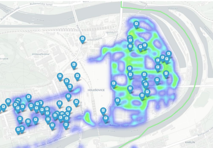
This evidence base enabled detailed spatial and temporal analysis of last-mile logistics activity. In both cities, high-frequency stopping areas and recurrent delivery corridors were identified. In Prague 7, the integration of delivery data with the district’s loading-zone inventory allowed the creation of heatmaps highlighting mismatches between infrastructure supply and actual delivery demand. In Las Rozas, aggregated indicators provided new visibility on route performance and freight intensity across different urban typologies.
Operational efficiency gains were also identified. In Las Rozas, analysis indicated the potential to reduce redundant delivery trips by 8-10%, corresponding to an estimated 5,000-6,000 avoidable trips under broader deployment scenarios. More broadly, the platform reduced manual planning effort, improved transparency of logistics flows and enabled municipalities to base mobility and space-management decisions on measurable operational evidence rather than assumptions.
Lessons learnt
One of the main challenges encountered during deployment was the alignment of data formats and operational practices between logistics operators and city administrations. Ensuring consistent data integration required additional coordination, iterative refinement and continuous technical support. User onboarding also highlighted the importance of clear guidance and simplified workflows to maximise adoption.
At the same time, close collaboration between municipalities and operators proved essential to validating and improving the solution. Early stakeholder engagement, structured feedback loops and regular review sessions significantly accelerated platform refinement and ensured that outputs were relevant for both operational and planning needs.
Overall, the pilots demonstrated that data-driven logistics monitoring is technically feasible and strategically valuable in both mixed and dense urban environments. However, successful replication depends not only on technology, but also on establishing trusted data-sharing frameworks and sustained cooperation between public and private actors. With these conditions in place, the solution shows strong potential for scaling to other European cities seeking more efficient, coordinated and sustainable last-mile logistics management.