Automatic night-time visibility analysis for vulnerable road users

The Challenge
European cities face increasing difficulties in achieving Vision Zero and ensuring the safety of vulnerable road users (VRUs). The rapid growth of micro-mobility (e-scooters, bicycles) and its interaction with private and delivery vehicles has led to a rise in urban accidents, especially during nighttime and low-light conditions such as dusk and dawn. While human behaviour plays a role in some incidents, a significant proportion could be prevented through improved infrastructure, including safer separation of traffic flows, clearer signage and adequate illumination of pedestrian crossings.
However, evaluating nighttime visibility across entire urban networks remains a major limitation. Current methods rely on visual inspections and manual luxmeter measurements, which are time-consuming, inconsistent and not scalable to city-wide deployment. Repeating these measurements across all intersections and under varying weather and seasonal conditions is practically unfeasible.
In cities such as Las Rozas de Madrid, Brașov and Vitoria-Gasteiz, lighting conditions are highly heterogeneous. Vegetation, construction works and even decorative lighting can reduce visibility or create a false sense of safety. As a result, municipalities lack reliable tools to systematically identify hazardous locations and assess lighting interventions. This creates a clear need for an automated, objective and scalable solution to continuously evaluate night-time visibility and support data-driven safety.
The Solution
This project developed and validated a computer vision-based system called the Autonomous Urban Inspector for Lighting, designed to automatically evaluate night-time urban visibility. The system detects and localises lighting infrastructure, such as streetlight poles and analyses the visibility conditions created by artificial lighting in real traffic environments.
The solution is composed of three integrated components. First, vehicles equipped with on-board devices (e.g., municipal maintenance or waste collection fleets) collect geo-referenced video and sensor data while driving through selected urban areas. Second, this data is processed in the cloud using computer vision algorithms to estimate visibility levels and generate aerial-like representations of lighting conditions, enabling the identification of poorly illuminated or unsafe zones. Third, a web-based application provides urban authorities and maintenance teams with an interactive GIS platform, where results can be visualised together with direct access to collected images and video evidence.
The system has been enhanced through pilot deployments in cities such as Vitoria-Gasteiz, Las Rozas and Brașov, where it successfully identified critical low-visibility areas and supported targeted interventions, such as vegetation pruning and streetlight replacement. Post-intervention re-evaluations confirmed the effectiveness of the improvements, demonstrating the system’s capability to support urban lighting optimisation.
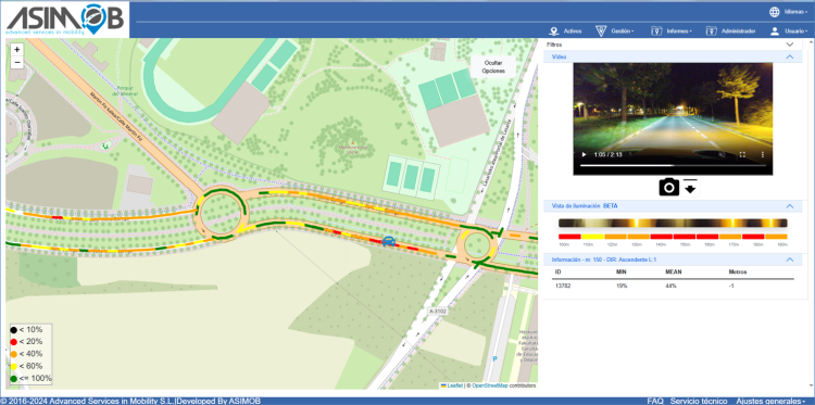
Web application for data analysis
Making an impact
The implementation of the Autonomous Urban Inspector for Lighting has a direct impact on road safety and urban mobility quality. Improved night-time visibility in areas where vulnerable road users (VRUs) share space with motorised traffic contributes to a reduction in traffic accidents involving pedestrians, cyclists and micromobility users such as scooters. It also supports safer conditions that can encourage a higher uptake of sustainable transport modes during dark hours.
Quantitative results from pilot cities show measurable safety benefits. The updated locations can achieve an estimated 10% reduction in traffic incidents in Las Rozas and 10% in Brașov in one year, demonstrating the effectiveness of data-driven lighting improvements. In addition, improvements in perceived safety are associated with increased use of vulnerable mobility modes.
Beyond local results, a key impact is scalability. The system reduces the time required for decision-making by enabling continuous, automated monitoring of all streets using existing municipal fleets, achieving near 100% network coverage compared to previously manual, location-based assessments. This significantly improves efficiency, reducing analysis cycles to approximately six months and enables cities across Europe to adopt a transferable, data-driven approach to night-time road safety management.
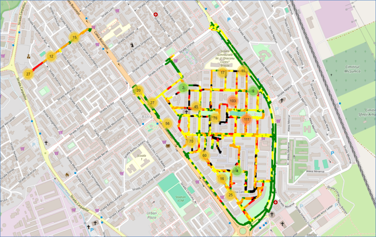
Analysis of visibility in Brasov
Lessons learnt
At the beginning of the project, it was assumed that the main factor affecting night-time visibility was primarily the distribution and placement of street lighting poles. However, the pilot implementations revealed that urban nighttime visibility is a much more complex and dynamic problem.
One key lesson is the strong influence of vegetation. Trees and other urban greenery can significantly block or redirect artificial lighting, and this effect changes throughout the year as vegetation grows or is pruned. This introduces a seasonal variability that must be considered when assessing lighting performance.
Another important finding is that street redesign and urban transformation projects have a direct impact on visibility conditions. The introduction of bike lanes, pedestrian areas, green zones and lane separations can alter traffic patterns and modify how light is distributed across the street environment. These changes are not always reflected in lighting planning, leading to unexpected visibility issues.
Finally, effective improvement of urban lighting requires strong interdepartmental coordination within municipalities. Lighting services, gardening teams, public works and mobility departments all influence night-time visibility conditions. Without coordinated planning and shared data, interventions may be delayed or less effective.
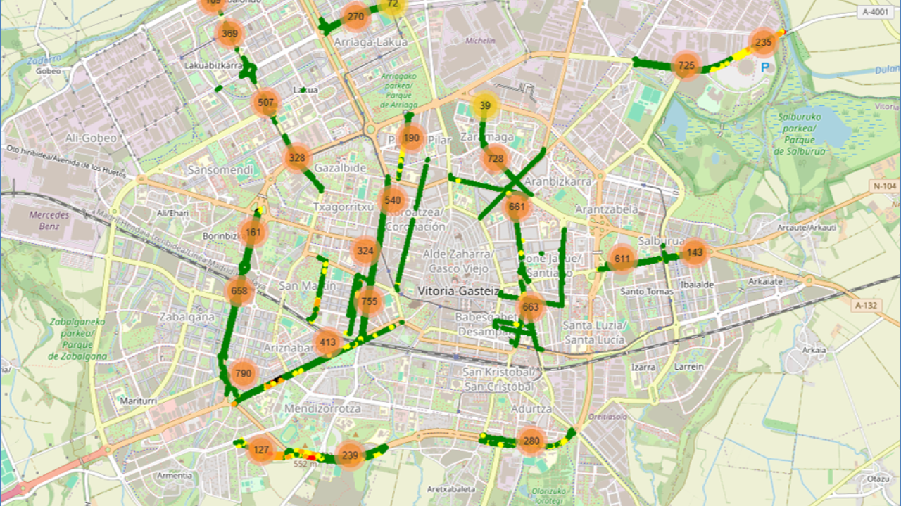
Analysis of visibility in Vitoria-Gasteiz
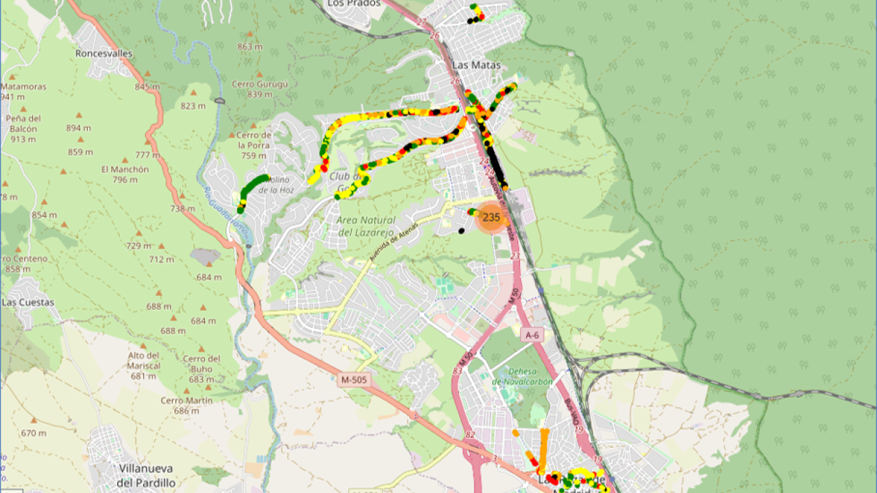
Analysis of visibility in Las Rozas
Analysis of visibility in Vitoria-Gasteiz
Analysis of visibility in Las Rozas