Explore market-ready mobility solutions across diverse needs and areas. Discover innovations proven to positively impact global smart cities.

Parkly: Modular urban furniture
Parkly's multifunctional and modular urban furniture helps to rap...
Find out more...
Citizen's Needs by Urban Radar
Proximity based urban planning and 15-min city to meet citizen's ...
Find out more...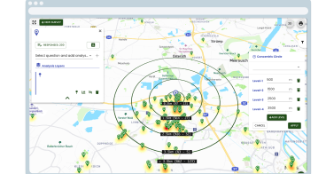
Mapalyse: Public Participation GIS Tool
Increase citizen engagement by collecting public opinions to understan...
Find out more...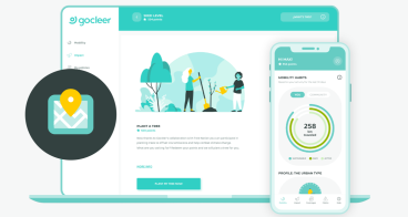
Gocleer: Mobility Data Platform
A modular platform to help insurers, corporates and city councils to e...
Find out more...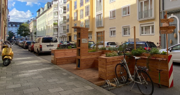
SET: Street Experiments Tool
SET helps to implement street experiments (quick and low-cost interven...
Find out more...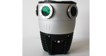
Mosaic X: 360º camera for 3D modelling and mapping
Mosaic X is a purposely-built, top quality mapping camera that allows ...
Find out more...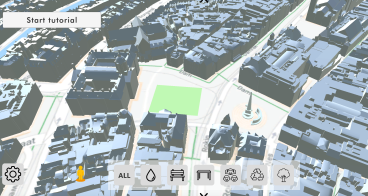
ModelMe3D: Immersive Co-Design of Public Spaces
ModelMe3D is the only co-design platform in the world where costumers ...
Find out more...
RAPID: 3D Prototyping
Early prototyping of mobility infrastructure changes, along with invol...
Find out more...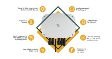
Smart Spot
IoT device for environmental parameter sensoring. The inclusion of all...
Find out more...
Environmental data analysis & visualisation
Hopu’s SaaS is an evidence-based air quality solution with high accura...
Find out more...
Mosaic: Mobile Street Mapping Service
Mosaic’s Mobile Street Mapping Service gathers large amounts of accura...
Find out more...