Holoscene
Mobile reality capture for cities. Make city infrastructure decisions with Holoscene, a LiDAR-based reality- solution that turns everyday rides into verified street-level insights.
Supported by: EIT Urban Mobility
Product Details
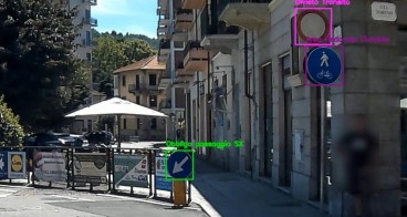
This is a mobile LiDAR-based reality-capture platform for urban mobility that transforms everyday rides into high-precision street-level data. Using LiDAR, cameras, and GNSS/IMU with on-board AI, it captures how mobility truly happens in real environments, recording road geometry, user interactions, safety conditions, and the state of public-space infrastructure with centimetre-level accuracy.
Cities and operators receive verified, GIS-ready insights they can use to improve safety, assess infrastructure, evaluate policies, plan investments, and track sustainability goals. Delivered as a flexible service, the solution co-designs pilot corridors or provides continuous monitoring through subscription-based data streams. The platform enables municipalities to move from assumptions to evidence, turning real journeys into actionable insights for safer, smarter, and more sustainable streets.

Availability
Discover cities and markets where the product is available