Planning safe cycling infrastructure in Istanbul

The Challenge
Istanbul faces a multifaceted set of mobility and safety challenges that constrain the development of a continuous, safe, and attractive cycling network. While the municipality has committed to expanding cycling infrastructure by more than 150–250 km, the existing network is highly heterogeneous in design quality, safety performance, and user experience. Many cycling corridors suffer from discontinuities, abrupt lane reductions, unclear signage, and frequent exposure to mixed traffic, all of which reduce comfort and increase risk for cyclists.
These infrastructure gaps are compounded by Istanbul’s complex urban context. High traffic density, rapid urbanisation, and varied topography—including steep gradients in several districts—create additional barriers to safe cycling. Furthermore, cycling culture remains uneven across neighbourhoods, limiting adoption and reinforcing reliance on motorised transport.
A critical barrier before the pilot was the lack of systematic tools to assess cycling infrastructure at scale. Existing approaches relied heavily on fragmented GIS datasets and labour-intensive field surveys, making it difficult to evaluate network performance consistently or compare alternative design scenarios. This limited the city’s ability to prioritise interventions and align investments with Sustainable Urban Mobility Plans (SUMPs).
As a result, Istanbul required a scalable, data-driven, and replicable methodology to assess infrastructure quality and identify risks.
The Solution
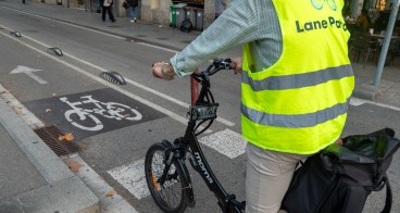
The pilot introduced Lane Patrol, a digital platform designed to enable large-scale, evidence-based assessment and planning of cycling infrastructure. The solution combined multiple data sources and analytical methods into a unified workflow tailored to Istanbul’s urban context.
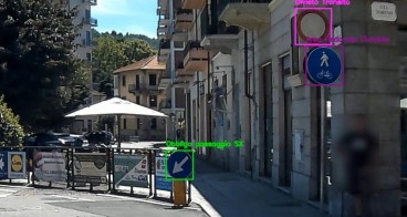
At its core, the platform leveraged an OpenStreetMap (OSM)-based light assessment approach to remotely analyse 150 km of streets across priority corridors. This was complemented by integration with Mapillary imagery, Street View verification and city-provided GIS and CAD datasets, allowing planners to access detailed information on road geometry, lane widths, traffic speeds and signage. Where data gaps existed, attributes were manually completed, ensuring comprehensive and reliable datasets.
The methodology was aligned with CycleRAP principles, enabling the generation of safety and comfort scores based on internationally recognised standards. In addition, a 30 km in-situ Lane Patrol survey provided high-resolution data for corridor-level analysis, enriching the overall assessment.
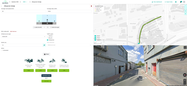
A key feature of the solution was its scenario simulation capability. Planners could test alternative street designs, evaluate risk levels and prioritise interventions based on quantified evidence. Dashboards were developed to support continuous monitoring and strategic planning.

Making an impact
The Istanbul pilot delivered tangible social, economic and environmental benefits by enabling faster, more accurate and scalable cycling infrastructure assessments. A total of 150 km of streets were remotely analysed using the OSM-based methodology, including high-priority corridors identified for redevelopment. This significantly reduced the time and cost associated with traditional field surveys, demonstrating a more efficient approach to network evaluation.
Key impact indicators include:
- 150 km of cycling infrastructure assessed through remote and in-situ methods
- 30 km of detailed, high-resolution surveys conducted for corridor-level analysis
- 35 trained stakeholders equipped with practical skills in data interpretation and scenario planning
- Priority corridors identified and ranked based on quantified safety and comfort scores
The platform enabled the identification of hazardous segments and key risk factors, such as excessive traffic speeds, insufficient lane separation and suboptimal lane allocation. Scenario simulations allowed planners to test interventions - such as protected cycling lanes - and assess their impact before implementation.
At neighbourhood level, the analysis provided actionable insights into traffic management and infrastructure redesign, supporting more targeted and effective interventions. The pilot also strengthened institutional capacity within the municipality, fostering a shift toward data-driven decision-making.
Lessons learnt
The Istanbul pilot confirmed that OSM-based light assessment combined with CycleRAP methodology and Mapillary video provides a robust framework for large-scale cycling infrastructure evaluation. Where OSM or CAD/GIS data lacked specific attributes such as lane widths, speed limits, or signage, these could be efficiently supplemented manually via Street View, demonstrating a practical workflow for comprehensive assessments.
The Hands-on workshops with 35 city stakeholders proved effective in building capacity, enabling users to interpret results, run scenario simulations and integrate insights into planning decisions. Scenario testing allowed rapid comparison of alternative street designs and prioritisation of interventions on 150 km of high-priority roads, supporting evidence-based decision-making.
Lessons learnt include the value of combining multiple data sources for complete assessments, embedding training to ensure effective platform use and leveraging scenario analysis to guide planning. These approaches enhance the scalability and replicability of Lane Patrol, providing a practical, data-driven model for cities to plan safer, more connected cycling networks efficiently.