Tech City Living Lab in Aveiro, Portugal

The Challenge
Prior to the establishment of the Aveiro Tech City Living Lab (ATCLL), the city of Aveiro was facing substantial limitations in terms of urban intelligence, digital infrastructure, and real-time data availability. Specifically, the lack of an integrated, citywide platform capable of collecting, processing, and acting upon mobility and environmental data.
Urban mobility management was constrained by the absence of detailed traffic monitoring systems, making it difficult to identify congestion patterns, understand vehicle flows, or respond to road incidents with appropriate, timely measures. Crossings and intersections lacked real-time risk detection systems, increasing the likelihood of accidents for vulnerable road users.
There was also a lack of infrastructure to support services such as collision warnings or emergency vehicle prioritisation. Public vehicles were not equipped with devices to measure and transmit environmental variables, nor was there a systematic way to assess people flow across urban areas.
Aveiro lacked the digital capacity to support edge and cloud computing capabilities distributed across the city, preventing the deployment of latency-sensitive services like real-time video analytics.
Aveiro was also lacking a testbed where universities, researchers, start-ups and companies could prototype new solutions in a real-world urban context.
The Solution
Aveiro Tech City Living Lab (ATCLL) is a large-scale urban platform deployed to address Aveiro’s pressing challenges in mobility, safety, environmental monitoring and smart infrastructure.
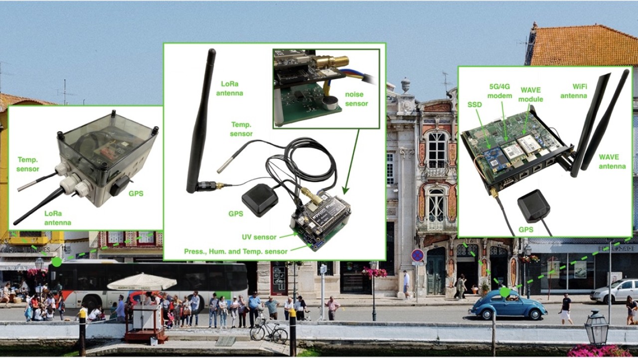
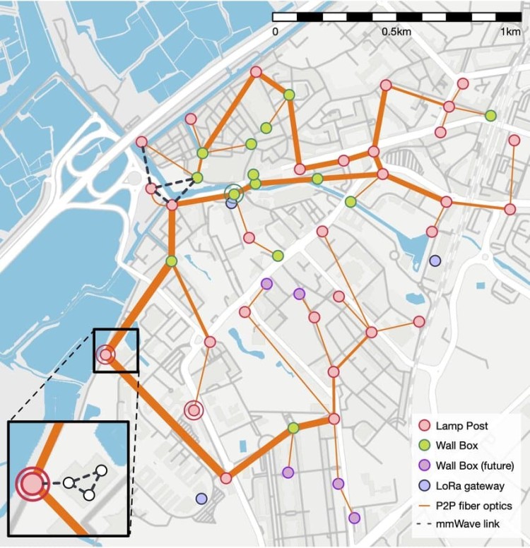
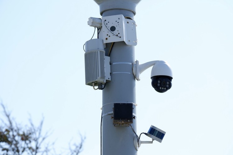
Following the principles of the physical internet, the system comprises 44 fixed access points, installed as Smart Lamp Posts or wall-mounted boxes. These points integrate multi-protocol wireless technologies, including ITS-G5, C-V2X, WiFi, 4G/5G and LoRaWAN, enabling robust, citywide connectivity.
Access points are equipped with edge computing units and a range of sensors: traffic radars, LiDARs, video cameras, and spectral probes. Mobile sensing devices installed on public vehicles (10 active, with plans to expand to 30) enable collection of mobility and environmental data including GPS, speed, temperature, humidity and air pressure.
The platform enables:
- high-resolution, real-time analysis of urban dynamics, supporting targeted traffic and safety interventions,
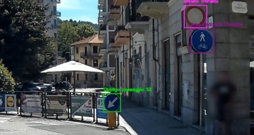
- real-time pedestrian and object detection through deep learning models (YOLOv3 and Nvidia DeepStream),
- collision avoidance mechanisms,
- real-time routing support for emergency vehicles,
- third party access (for researchers, start-ups and public agencies) for experimental deployments, data analysis or service prototyping
Combining multi-technology communication, edge computing, sensor fusion and open data infrastructure, ATCLL directly addresses Aveiro’s limitations, offering a scalable, replicable model for future smart cities.
Making an impact
Through its distributed sensing and communication infrastructure, ATCLL generated robust citywide datasets that allow detailed analysis of traffic flow, vehicle behaviour, pedestrian presence, and environmental parameters. Key outcomes include:
Real-time characterisation of mobility patterns. Between 7-11 February 2022, traffic radars installed at ISCA-UA and Dobadoura bridge recorded detailed hourly vehicle counts. ISCA-UA registered ~500 vehicles/hour, while Dobadoura bridge recorded ~150–170 vehicles/hour during morning rush hours. This data enabled the city to identify temporal congestion peaks, and compare flows between major entry points.
Pedestrian activity analysis enabled by edge video detection. At a crosswalk monitored by a Smart Lamp Post near ISCA-UA, the system counted the number of pedestrians per video frame each hour. On 8 February 2022, data showed pedestrian peaks around 8am, correlating with reduced vehicle speed and increased congestion.
Enhanced vehicular network performance. Connectivity tests showed packet loss below 5% and throughput reaching >8 Mbps in several RSUs, while ITS-G5 vs 5G mapping showed reliable switching depending on urban coverage. In collision prevention trials, alerts achieved median delivery times of 89ms, enabling timely warnings for vehicles and vulnerable road users.
Lessons learnt
One key challenge was the integration of heterogeneous technologies, including ITS-G5, 5G, edge computing, and various sensing devices. Ensuring interoperability and seamless communication between different protocols required a modular, flexible system architecture, essential for adapting to evolving technologies.
Managing the variability of network coverage, particularly the dynamic switching between ITS-G5 and 5G presented a challenge. Maintaining reliable connectivity in complex urban environments highlighted the need for continuous monitoring and dynamic network optimisation to ensure consistent performance.
The project underscored the critical role of edge computing in reducing data processing latency. Edge processing enabled real-time pedestrian detection and traffic alerts with low latency, crucial for safety-critical scenarios. Distributed computing infrastructure is key for responsive, scalable smart city solutions.
Engagement with stakeholders – researchers, startups, and public institutions – presented an opportunity for improvement. While the platform was designed to be open and collaborative, sustaining active participation is vital for long-term success.
The modular, open and technology-agnostic design of ATCLL holds significant potential for replication in other urban contexts. Combining edge computing with hybrid communication technologies and fostering stakeholder collaboration offers a replicable model for enhancing urban mobility, safety, and sustainability.